Regions of Costa Rica
Top 5 Cantons of Cartago Province
Cartago province, east of San José, has 8 cantons; its first 5 by official number are Cartago, Paraíso, La Unión, Jiménez and Turrialba. This guide lists their current districts from the 2025 official territorial division, with notes on the Orosi Valley, Turrialba and the old colonial capital.
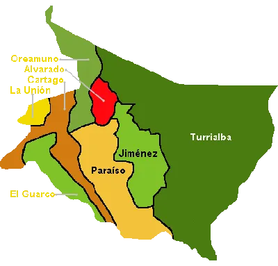
Costa Rica is divided into 7 provinces, 84 cantons (counties, each with its own municipality) and about 490 districts. Every canton has an official number within its province. This article covers Cartago province's first 5 cantons by that number, numbers 1 to 5, rather than a ranking. Areas and district lists come from the official 2025 territorial division published by Costa Rica's government.
Cartago province lies east of San José, in the highlands around the Irazú and Turrialba volcanoes and down into the Reventazón river valley. It has 8 cantons, and its capital is the city of Cartago.
1. Cartago
The city of Cartago was Costa Rica's colonial capital until the capital moved to San José in 1823, and the canton is named as the province's first in the 1848 decree. Today it's a busy city about 25 km east of San José, linked to the capital by road and a commuter train, and best known for the Basilica of Our Lady of the Angels.
Area: about 279 km². Districts (11): Oriental, Occidental, Carmen, San Nicolás, Aguacaliente (San Francisco), Guadalupe (Arenilla), Corralillo, Tierra Blanca, Dulce Nombre, Llano Grande and Quebradilla.
2. Paraíso
Paraíso, just southeast of Cartago, includes the Orosi Valley, a popular drive from San José, with coffee farms, the colonial church ruins at Ujarrás and the Cachí reservoir. Its Orosi district runs up to Tapantí. Its newest district is Birrisito.
Area: about 477 km². Districts (6): Paraíso, Santiago, Orosi, Cachí, Llanos de Santa Lucía and Birrisito.
3. La Unión
La Unión, whose main town is Tres Ríos, sits between San José and Cartago and is now largely part of the capital's suburbs. At about 44 km², it's the smallest canton in the province by area.
Area: about 44.2 km². Districts (8): Tres Ríos, San Diego, San Juan, San Rafael, Concepción, Dulce Nombre, San Ramón and Río Azul.
4. Jiménez
Jiménez was created in 1903, split from Paraíso along with Turrialba. Its main town is Juan Viñas, a farming town on the road between Cartago and Turrialba. It now has 4 districts, including La Victoria, the newest.
Area: about 250 km². Districts (4): Juan Viñas, Tucurrique, Pejibaye and La Victoria.
5. Turrialba
Turrialba, also created in 1903, is by far the province's largest canton, at about 1,590 km². The town of Turrialba sits at about 650 m. The canton is known for white-water rafting on the Pacuare and Reventazón rivers, the Turrialba Volcano, and the Guayabo National Monument, a pre-Columbian archaeological site.
Area: about 1,589 km². Districts (12): Turrialba, La Suiza, Peralta, Santa Cruz, Santa Teresita, Pavones, Tuis, Tayutic, Santa Rosa, Tres Equis, La Isabel and Chirripó.
Yoga in the province
Cartago is a day trip rather than a yoga base, but the Orosi Valley and Turrialba make a calm stop before or after a retreat. We once listed Yoga Sol in the city of Cartago, but couldn't confirm it still runs. The nearest open studio we know of is Yoga Mandir in San Pedro, on the Cartago side of San José. For retreats, see where to do yoga in Costa Rica.
Frequently asked questions
What is a canton in Costa Rica?
A canton is the level of local government below the province, roughly like a county, with its own elected municipality. Each canton is split into districts.
How many cantons does Cartago province have?
8, according to the official 2025 territorial division.
How far is Cartago from San José?
About 25 km east. You can drive, take a bus, or ride the commuter train between the two cities.
[Updated on: 4 November 2026]